Spatial Analysis Leveraging Geographic Information System and Kernel Density Estimation for Crime Prediction
DOI:
https://doi.org/10.69478/JITC2024v6n2a10Keywords:
Kernel density estimation algorithm, Mapping, Crime analysis, Antique, QGISAbstract
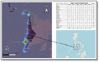
This study explored the potential of spatial analysis techniques to predict crime hotspots and coldspots within the province of Antique, Philippines. The unique blend of geographical features (coastal and mountainous regions) and socio-economic characteristics in Antique presented a compelling opportunity for the research. Crime data from 2018 to 2023, encompassing direct assaults, homicides, murders, and parricides, was acquired from the Police Regional Office 6. Using Quantum Geographic Information System (QGIS) software and Kernel Density Estimation (KDE) algorithms, the researchers analyzed these crime records. The findings highlighted a positive trend – a decrease in direct assaults over the study period. However, homicide data presented a more concerning picture, with specific locations consistently reporting higher rates. While murder cases showed a decline, parricide incidents remained relatively low, with occasional fluctuations. In conclusion, this data-driven approach, utilizing advanced crime analysis tools, offers valuable insights for policymakers in Antique. By investing in such technology and adopting data-driven strategies, policymakers can work towards creating a safer and more secure future for their communities.
Downloads
Published
License
Copyright (c) 2024 Roger S. Mission

This work is licensed under a Creative Commons Attribution-NonCommercial 4.0 International License.

